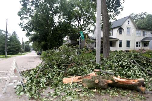
Several trees throughout Elburn were damaged after a derecho spawned at least 11 confirmed tornadoes throughout Northern Illinois and Northwest Indiana Monday.
Sandy Bressner/Shaw Local News Network
National Weather Service survey teams have confirmed six more tornadoes touched down during Monday night’s derecho.
That brings the total number of confirmed tornadoes to 11.
The teams are also continuing to investigate dozens of other sites where potential twisters touched down during the storm and meteorologists at the Romeoville office expect the number of confirms tornadoes to rise throughout the week.
ComEd officials are reporting more than 60,000 customers remain without power, according to the company’s website.
One person was killed in Northwest Indiana when a tree branch broke loose and crashed onto a house, collapsing the roof on a woman in bed, authorities said.
According to weather service reports, the first confirmed tornado in our region touched down around 7:40 p.m. in southern Winnebago County and was categorized as an EF-0, the least damaging type.
Another EF-0 tornado struck near Byron in Ogle County at 7:44 p.m. Peak winds reached 80 mph and the path of the tornado was 5 miles long and reached a maximum width of 200 yards. The tornado caused tree damage in some areas and blew roofing materials off a car wash.
Another EF-0 tornado touched down near Ogle County’s Davis Junction at 7:58 p.m. and ran less than two miles straight east with peak wind speeds of 80 mph with a maximum width of 200 yards. Damage was limited to trees, survey teams reported.
At 8:52 p.m., another EF-0 tornado dropped near Sugar Grove and spent 10 minutes on the ground for nearly eight miles until it reached North Aurora. This tornado reached peak wind speeds of 85 mph and was 250 yards wide at its worst.
The first EF-1 tornado confirmed touched down at 8:55 p.m. near Yorkville and then kept going for 20 minutes until it reached southern Naperville nearly 17 miles later. Peak winds speeds reached 100 mph and the twister also had a maximum width at times of 200 yards. Survey teams said trees along the tornadoes path were uprooted or snapped and there was some reported property damage as well.
Another EF-1 tornado was confirmed at 9:17 p.m. near Channahon. This twister snapped power lines over Interstate 55, which is still closed in both directions as crews work to rebuild the electric infrastructure there. The tornado ran at least 25 miles to Matteson in Will County with peak wind speeds of 105 mph and a maximum width at times of 200 yards.
An EF-0 tornado was confirmed in Crest Hill at 9:21 p.m. and lasted nine minutes as it sped 6 miles east to Lockport. At it’s peak, the twister was 200 yards wide with wind speeds topping out at 75 mph.
At 9:37 p.m., an EF-1 tornado touched down near Justice in southern Cook County with winds of up to 90 mph. The tornado was 75 yards wide and lasted a little over two miles.
Chicago’s near west side and west loop area was hit with a tornado that reached 600 yards wide at times at 9:47 p.m. The EF-1 twister with peak wind speeds of 95 mph uprooted trees and caused minor structural damage along its 3-mile path, survey teams reported.
Another EF-1 tornado touched down in the Chicago Lawn neighborhood of Chicago at 9:47 p.m. and ran northeast for six minutes into West Englewood three miles away. The tornado’s speeds topped out at 95 mph and had a maximum width of 175 yards.
An EF-1 tornado in Northwest Indiana that stretched between Cedar Lake and Crown Point spent five minutes on ground going northeast for less than five miles. At its peak, wind speeds were 90 mph and it stretched 300 yards wide, survey teams reported. It touched down at 9:56 p.m.
The derecho, a weather term for a straight-swath storm system covering hundreds of miles with a long life and a fast-moving line of showers and thunderstorms, started earlier in the day in Iowa and then fed off the cooler evening air as it carried east, meteorologists said.
